


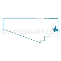
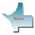
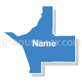
Voting District 221, Pima County, Arizona
About
Outline

Summary
| Unique Area Identifier | 525328 |
| Name | Voting District 221 |
| County | Pima County |
| State | Arizona |
| Area (square miles) | 146.32 |
| Land Area (square miles) | 146.32 |
| Water Area (square miles) | 0.00 |
| % of Land Area | 100.00 |
| % of Water Area | 0.00 |
| Latitude of the Internal Point | 32.01850280 |
| Longtitude of the Internal Point | -110.58589360 |
Maps

Graphs
Select a template below for downloading or customizing gragh for Voting District 221, Pima County, Arizona


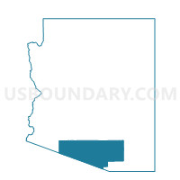
Neighbors
Neighoring Voting District (by Name) Neighboring Voting District on the Map
- Voting District 11, Pima County, AZ
- Voting District 274, Pima County, AZ
- Voting District 276, Pima County, AZ
- Voting District 374, Pima County, AZ
- Voting District 388, Pima County, AZ
- Voting District 390, Pima County, AZ
- Voting District 393, Pima County, AZ
- Voting District 409, Pima County, AZ
- Precinct 02, Cochise County, AZ
Top 10 Neighboring County Subdivision (by Population) Neighboring County Subdivision on the Map
Top 10 Neighboring Place (by Population) Neighboring Place on the Map
- Tucson city, AZ (520,116)
- Vail CDP, AZ (10,208)
- Rincon Valley CDP, AZ (5,139)
- Mescal CDP, AZ (1,812)
- Pimaco Two CDP, AZ (682)
Top 10 Neighboring Elementary School District (by Population) Neighboring Elementary School District on the Map
Top 10 Neighboring Unified School District (by Population) Neighboring Unified School District on the Map
- School District Not Defined, AZ (69,809)
- Vail Unified District, AZ (52,532)
- Benson Unified School District, AZ (8,210)
Top 10 Neighboring State Legislative District Lower Chamber (by Population) Neighboring State Legislative District Lower Chamber on the Map
- State House District 30, AZ (231,236)
- State House District 25, AZ (208,220)
- State House District 29, AZ (184,459)
Top 10 Neighboring State Legislative District Upper Chamber (by Population) Neighboring State Legislative District Upper Chamber on the Map
- State Senate District 30, AZ (231,236)
- State Senate District 25, AZ (208,220)
- State Senate District 29, AZ (184,459)
Top 10 Neighboring 111th Congressional District (by Population) Neighboring 111th Congressional District on the Map
Top 10 Neighboring Census Tract (by Population) Neighboring Census Tract on the Map
- Census Tract 41.07, Pima County, AZ (8,521)
- Census Tract 40.64, Pima County, AZ (7,696)
- Census Tract 40.62, Pima County, AZ (5,398)
- Census Tract 41.09, Pima County, AZ (5,304)
- Census Tract 3.02, Cochise County, AZ (4,851)
- Census Tract 40.61, Pima County, AZ (4,821)
- Census Tract 3.03, Cochise County, AZ (3,457)
- Census Tract 40.74, Pima County, AZ (2,039)